Tag: Boston

Walk on State Street? Public Works wants to make it safer. Make sure to weigh in!

Walk on State Street? Public Works wants to make it safer. Make sure to weigh in!

In January 2020, Boston’s Public Works Department announced they would be taking a look at State Street in downtown Boston for major upgrades. This effort builds on previous planning projects and initiatives that the City of Boston has rolled out over the last few years: GoBoston 2030, Vision Zero, Complete Streets guidelines, and Connect Historic Boston. As the Boston Globe’s Adam Vaccaro put it at the time:

[O]fficials say there’s one primary goal: to make State Street much better for walking. That’s not just a matter of urban idealism: State Street is overwhelmingly used by pedestrians, with more than 29,000 each day compared with about 10,700 cars and trucks.

Everyone can agree there has long been a need to expand the narrow/uneven sidewalks, which especially during lunchtime can be wholly inadequate.

However, there is also a need to make the street easier to cross. In November 2019, a driver struck a 86-year old woman just after the morning rush hour; the woman suffered life-threatening injuries.

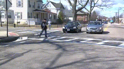
One-way streets with multiple lanes of vehicle traffic are inherently dangerous for people walking. When a driver stops for a pedestrian to let them cross at an unsignalized crosswalk, a driver in the second lane may not see the person trying to walk across the street, resulting in a dangerous scenario called the “double threat.”

Over the last year, the Public Works team steadily moved the project along using pre-COVID-19 traffic and parking data for modeling. They convened a group to meet with their team remotely each month throughout the summer to discuss and react to options for this stretch of street that connects the Rose Kennedy Greenway to the Old State House.

In the fall, State Street became one of the locations for a “Healthy Streets” pilot project, in which cones were deployed to create temporary wider-sidewalks and a bike lane to allow for social distancing. It is great that the Transportation and Public Works departments collaborated to test concepts here for a future redesign.

In October, Boston’s Public Works Department (PWD) presented four design options for long-term improvements to State Street. (You can see a PDF of the presentation here, watch a narrated video of the presentation here, and fill out the survey here.)

The Public Works Department is responding to the need to make streets safer for pedestrians, and they need to hear from you now!

The project status is listed as “in design,” and a design survey is currently open. We highly encourage you to weigh in on making this a street that is safer for people walking. More sidewalk space, a protected bike lane, and space for loading zones means less exposure to moving vehicle traffic for people walking, resulting in safer street crossings. There has been pushback that reducing space for people driving is a bad idea, with a claim that these plans are based on pandemic traffic volumes. However, data that informed the concepts are pre-pandemic, as the Public Works Department made clear in the presentations.

Here’s what you can do

WalkBoston, LivableStreets Alliance, Boston Cyclists Union – 80 West Broadway Project Comment Letter

WalkBoston, LivableStreets Alliance, Boston Cyclists Union – 80 West Broadway Project Comment Letter

February 12, 2021

Stephen Harvey
BPDA
Boston City Hall

Re:  80 West Broadway Project

Dear Mr. Harvey,

It has come to our attention that issues related to pedestrians and bicyclists are being used as a reason to demolish the historic Amrheins building at the corner of West Broadway and A Streets in South Boston. We do not see that removal of that building and widening of the sidewalk at that location will serve any real benefit to pedestrians and cyclists, with there being no likelihood of additional modifications of the public way just past this building on either Broadway or A Street.

This is not a reason to demolish this historic resource. Other minor modifications such as removal of the bollards on A Street, adjustments to signaling, and perhaps a bump out of the sidewalk on West Broadway directly in front of Amrheins could enhance the situation with far less cost and impact.

We have much higher priority areas in the city that require strong advocacy. Advancing pedestrian and bike challenges as the foremost issue in this location does not make sense to us. This is not an intersection that requires the level of dramatic intervention being proposed and certainly should not be used as justification for demolition of a building long part of the city’s historic fabric.

Best regards,

Stacey Beuttell, Executive Director WalkBoston

Stacy Thompson, Executive Director LivableStreets Alliance

Becca Wolfson, Executive Director Boston Cyclists Union


Cc
Jonathan Greeley, Boston Planning and Development Agency
Michael Cannizzo, Boston Planning and Development Agency
Alexa Pinard, Boston Planning and Development Agency
Elizabeth Stifel, Boston Civic Design Commission
Andrea Leers, Boston Civic Design Commission
B.K. Boley, Stantec
John Matteson, Matteson Companies
Doug Kelleher, Epsilon Associates
Representative Stephen Lynch, 8th District, United States Congress
Kim Janey, President, Boston City Council
Ed Flynn, Boston City Council
Annissa Essaibi George, Boston City Council
Michael Flaherty, Boston City Council
Julia Mejia, Boston City Council
Michelle Wu, Boston City Council
Robert Allison, South Boston Historical Society
Greg Galer, Boston Preservation Alliance

WalkBoston, LivableStreets Alliance, Boston Cyclists Union Hook Wharf Project/15-17 Northern Avenue Comment Letter

WalkBoston, LivableStreets Alliance, Boston Cyclists Union Hook Wharf Project/15-17 Northern Avenue Comment Letter

February 12, 2021

Ebony DaRosa
Boston Planning and Development Agency
One City Hall Square
Boston, MA 02201

Via Email:  Ebony.DaRosa@Boston.gov

Re: Hook Wharf Project/15-17 Northern Avenue

Dear Ms. DaRosa:

WalkBoston, LivableStreets Alliance and the Boston Cyclists Union write with our comments regarding the redevelopment of the Hook Lobster site.

Project Concept

We see a number of things to like about the project including its addition to the Harbor Walk, its support of Hook Lobster with both indoor and outdoor space, its addition of new dining venues, the incorporation of separated bike lanes along Atlantic Avenue and the provision of no on site parking spaces. We believe that the mix of Harbor Walk, Seafood store and restaurants, and hotel are appropriate for this very public site.

Construction

We are also pleased that the developer will ensure that full Atlantic Avenue sidewalk access with overhead protection will be provided throughout the construction period. We also hope that the proponent will be able to use barges to move materials onto and off the site as was described during the January public meeting. We look forward to seeing more details about construction methods during subsequent filings with the BPDA and MEPA.

We do have several concerns which we ask that the proponent address in future filings, several of these concerns will require extensive coordination with City and State agencies.

Delivery and drop-off access to the site

Given the density of public facing uses on the site, including retail, restaurant, hotel and event space a significant number of vehicle trips will need to be accommodated on the site. As described in the PNF, these operations will take place both inside the loading dock within the building footprint, and alongside the hotel, both within the site and along the site in City-owned land in and adjacent to the Northern Avenue Bridge (NAB) right-of-way, including trucks and vehicles exiting the property via the NAB approach to Atlantic Ave.

We request that the proponent’s next filing include detailed information including:

  • The number of service deliveries and drop offs onto and off the site and into the building’s loading bays
  • The number of guest drop offs and pickups to/from the site per day
  • A diagram of the paths of vehicle movements on and off the site
  • Commit to providing personnel to manage the movements of vehicles

Alignment with the Northern Avenue Bridge

While the proponent has suggested a new layout for the Northern Avenue Bridge (NAB) approach area which straightens out the City’s proposed design and makes such use more feasible from a geometric perspective, we do not believe that the mix of shuttle buses, pedestrians, bikes, delivery trucks, cabs and TNCs that are now being proposed for this area will be safe or comfortable for people walking and biking.

We are also concerned that the elevation and alignment of the NAB is not properly reflected in this plan. To date the City has not provided a detailed design for how the approach of the bridge will connect to Atlantic Ave.

We would prefer that the proponent join with the overwhelming support from community members and our walking, biking and transit advocacy organizations to urge the City to reverse its decision to allow vehicles (other than emergency vehicles) on the NAB, and rather to develop a walking and biking bridge that could much more readily allow reasonable service access for the Hook Wharf Project and the Coast Guard Building which will also need to use the NAB approach for its service vehicles.

As people walking and biking will be the primary users of the NAB, and the users that the public has urged the City of Boston to make the focus of the NAB design, if an acceptable design is possible we believe that the proponent will need to develop an improved design for the NAB approach and the hotel service area. A detailed management plan, including dedicated staffing, will be needed to ensure the safety of people walking and biking onto and off the NAB and along Atlantic Avenue.

Future North-South Rail Link

The Hook site is where the tunnel would leave the Central Artery right-of-way to access South Station. Thus a Hook Wharf building piling at the wrong location could sever this route and prevent the Rail Link from ever being built. Since a final alignment for the N-S Rail Link has not been determined, the right-of-way must be preserved. And we urge the BPDA decision on Hook Wharf to explicitly require a design that allows for the future feasibility of a N-S Rail Link via the Central Artery alignment.

Thank you for the opportunity to comment on the project and we look forward to the next round of information and public meetings.

Stacey Beuttell, Executive Director, WalkBoston

Wendy Landman, Senior Policy Advisor, WalkBoston

Stacy Thompson, Executive Director, LivableStreets Alliance

Becca Wolfson, Executive Director, Boston Cyclists Union


Cc:
Jonathan Greeley, Boston Planning and Development Agency
Elizabeth Stifel, Boston Civic Design Commission
Andrea Leers, Boston Civic Design Commission
John Moriarty III, Moriarty Partners
David Manfredi, Elkus Manfredi Architects
William Zielinski, SKW Partners
Carol Chirico, GSA
Kim Janey, Boston City Council
Annissa Essaibi George, Boston City Council
Michael Flaherty, Boston City Council
Julia Mejia, Boston City Council Michelle Wu, Boston City Council
Ed Flynn, Boston City Council
Greg Galer, Boston Preservation Alliance
Sara McCammond, Fort Point Neighborhood Association

Dorchester Bay City Comment Letter

Dorchester Bay City Comment Letter

December 10, 2020
Director Brian Golden
Boston Planning and Development Agency
Attn via email: Aisling Kerr

Secretary Kathleen A. Theoharides
Executive Office of Energy and Environmental Affairs
Attn via email: Erin Flaherty

Re: Dorchester Bay City (EEA# 16277)

Dear Secretary Theoharides and Director Golden:

Dorchester Bay City has the potential to transform a significant site from a largely vacant expanse of asphalt into a vibrant place that draws people from across Boston and the region. Because the ground lease for the property will provide funding for UMass Boston, the site also carries with it an opportunity to strengthen the City’s most important public university.

WalkBoston has reviewed the ENF and PNF with the knowledge that there is a great deal more planning and design to come. We hope that our comments and questions will help to ensure that the scope for the EIR and PIR will help to make the project truly walkable for all.

We also hope that our comments will help to ensure that the proponents, other nearby development teams, and City and State public agencies come together to design and execute the on and off-site infrastructure needed to bring the site’s promise to fruition. The fact that the City’s CAC has been charged with thinking about the benefits, impacts and public infrastructure needs of a collection of projects is a hopeful sign that this bigger picture planning and investment will occur.

Our comments are focused on four key questions:

  1. How will Dorchester Bay City (DBC) achieve the walking connections to the Red Line needed to achieve the mode split envisioned – with relatively low levels of vehicle use and high levels of walking and transit use?
  2. How can DBC be more robustly connected to its immediate and more distant Dorchester neighbors?
  3. What role and responsibility should DBC take in resolving the significant transportation needs that the project’s success is contingent on?
  4. How can some of the site’s more detailed designs ensure that people walking are comfortable, safe and well served by the project itself.

JFK/UMass Station Walking Connections 

The documents describe the poor and unsafe walking connection between the site and the Red Line Station, but level of intervention described to improve the connection is not commensurate with mode share projection and the need of DBC’s occupants. The walking time estimates (shown with concentric circles) do not reflect the actual routes or the psychological barriers posed by the very busy roads and intersections that must be navigated.  Notwithstanding the improvements proposed for Mt. Vernon Street, WalkBoston remains concerned that the quality of the walking environment between the site and the MBTA station will not be attractive enough to generate the substantial transit and pedestrian mode splits that are projected (and which are needed to meet the City’s and State’s GHG targets as well as to prevent ever worsening congestion).

  • We urge the proponent (along with DCR and other public agencies) to think very creatively about this issue and to develop design interventions for the Mt. Vernon Street/Morrissey Boulevard at-grade and underpass intersections that are transformative.
  • We urge DBC to also look at possible walking connections via K Circle and Columbia Road which may be a shorter and more direct walk for some DBC users. The plans being developed for Day Boulevard Extension and for access to the Boston Teacher’s Union Building (5th Street on Figure 1-32 in the PNF) might serve as a starting point for that investigation.
  • As the project plans move ahead, the proponent should also provide a detailed marketing and program plan that will help to achieve the mode splits that have been shown in the ENF and PNF, including a reduction in the number of parking spaces proposed.

Neighborhood Connections

DBC should be connected to its neighbors and to Dorchester. WalkBoston is concerned that DBC will create an island of shiny buildings not connected to their neighbors or the rest of the City.

  • Harbor Point Walking Connection – The grading plans that are proposed to achieve the needed resiliency to ocean level rise will create a grade separation between Harbor Point and DBC. We request that the proponent provide more design details to describe how the physical and neighborly connection will be made between the sites.
  • UMass Walking Connection – UMass is only a five -minute walk from many parts of the DBC site. We ask that the project design team explore ways in which this connection can be made attractive and explicitly help to build a connection between the two.
  • Dorchester, Moakley Park, Carson Beach Connections –We understand that resolution of the design for Morrissey Boulevard and K Circle lies in the hands of state agencies and will be enormously important to these connection issues. But we urge the proponent to delve deeply into design ideas that could help make the walking connections robust. For example:
    • What wonderful walking path and Day Boulevard crossing could connect DBC to Moakley Park?
    • Are there improvements to walking connections via K Circle and Columbia Road that would also continue under the Southeast Expressway to make the walk to Dorchester Ave and beyond significantly more pleasant and fully accessible?

Role and responsibility of DBC in resolving the significant transportation projects

There are very big off site issues that need to be addressed to make this project really work. The proponent acknowledges that the infrastructure needs to match climate resiliency and the scale of the development that is coming on this site and nearby. The projects include JFK/UMass station and service; Morrissey Boulevard, K Circle and Day Boulevard that are re-built as a climate-resilient gateways that serve all modes.

We ask that DBC describe the level of commitment that they will provide to get these projects to successful implementation that goes beyond promises to collaborate and includes firmer commitments in terms of timing, leadership in bringing all parties to the table and funding.

Design Details

We understand that the PNF and ENF show very early stages of design, and ask that the following walking and walkability questions be addressed in greater detail in the DEIR and DPIR.

  • Provide separated walking and biking routes.
  • De-emphasize vehicles throughout the project site – slow them down, make them feel like intruders who have been granted access on good behavior.
  • Provide active places for playing, basketball etc. not just landscaping as a forecourt to buildings. DBC should achieve the lived-in, well-used feel of a neighborhood that feels like a place for everyone.
  • Re-examine the proximity of Building A to Carson Beach, which is public open space and should not feel privatized in any way.
  • Look in a very fine grained way at garage entries and exits, service and loading areas etc. to ensure that they are safe and gracious for people walking.

Thank you for the opportunity to comment on this significant and important development which will occupy on of Boston’s most wonderful sites.

We look forward to working with the DBC Team, the community and City and State agencies to help ensure that a wonderful project is built.

Sincerely,

Stacey Beuttell                                                                                  Wendy Landman
Executive Director                                                                           Senior Policy Advisor

Boston Herald: “Horror in Charlestown: Pedestrian killed after getting struck, dragged for a mile by vehicle”

Boston Herald: “Horror in Charlestown: Pedestrian killed after getting struck, dragged for a mile by vehicle”

Boston Herald: “Horror in Charlestown: Pedestrian killed after getting struck, dragged for a mile by vehicle

During the first five days of the new year, there have already been multiple fatal pedestrian crashes in Massachusetts, including a hit-and-run in Springfield over the weekend, said Brendan Kearney of the WalkBoston advocacy group.

“The number of large vehicles involved with fatal crashes, especially involving people walking or biking, is a huge concern,” he said. “And that’s not just in Boston, but across the state and across the country.

“There are bad sight lines on these vehicles,” Kearney added. “And it’s putting everyone in a bad situation when we have large vehicles and streets where people can drive fast.”

During the coronavirus pandemic, there have been fewer cars on the roads but drivers are speeding at a higher clip, he said.

“That’s something we’ve seen across the state,” Kearney said.

Posted January 5, 2021