Author: walkboston

Blind man walking (and running)!

Blind man walking (and running)!

image

Kyle Robidoux is the Director of  Volunteer & Support Group Services at the Mass. Assoc. for the Blind & Visually Impaired.

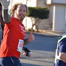
I walk everywhere. As a marathoner, I also run all throughout Boston and neighboring cities.

I’m also legally blind so walking, along with public  transit, is my main mode of transportation. Therefore,  walkability is very important to me and my family.

The walkability of the city and its public infrastructure impacts me every day. It impacts where I walk, how quickly I can get to where I need to be, and most importantly how safely I can get there.

As someone with low vision (I have very restricted central vision, similar to looking through a toilet paper roll), I rely on sidewalks, curb cuts and ramps, and crosswalks to get me safely to where I need to be. I use a white cane most of the time so the quality of sidewalks and streets is very important.

Brick sidewalks are one of the most unfriendly surfaces for me and most folks with limited mobility (I assume most sighted walkers, too). My cane tip frequently gets stuck in a missing brick or I trip because of the unevenness of the sidewalk. Old (some say historic) sidewalks are very common in the South End, where I spend a good majority of my time. If I have a choice, I will avoid going down a street if I know it has terrible brick sidewalks. I’m thankful that the city has set a new policy limiting the amount of brick in the walk path when repairing/installing new sidewalks.

As my eyesight decreases, I am becoming more reliant on audible street crossings. Otherwise, I have to ask someone to help me find the push button. It would be wonderful if more street crossings had regular intervals in which to cross or a “walk signal” triggered by a sensor on the closest curb ramp.

My relationship to the built environment in my neighborhood plays a large factor as my eyesight decreases, especially during the winter. Trying to navigate unshoveled sidewalks and curb cuts blocked by snowbanks is physically and mentally exhausting. I walk my daughter to school along the South Bay Harbor Trail. Sections of the trail were not plowed this winter days after a snowstorm. Some days my daughter and I, along with other students, were forced to walk in the street because the unplowed path was too difficult to walk.

As our communities continue to develop, I hope less time and energy is spent on talking about parking and traffic and more on creating accessible public spaces.

Creating accessible spaces is not only good public policy but will also ensure that they flourish and reach their greatest potential.

This article was featured in our Spring 2014 newsletter. See the full newsletter & past editions here.

——————————————————————————————————————-
Join our Mailing List to keep up to date on advocacy issues.

Like our work? Support WalkBoston – Donate Now!
Connect with us on Twitter and Facebook

Beacon Street Multimodal Improvements and Streetscape Enhancement Comment Letter

Beacon Street Multimodal Improvements and Streetscape Enhancement Comment Letter

The Beacon Street project area extends from the bridge abutment at Oxford Street to Dickinson Street, a distance of approximately 1.1 miles. The project is intended to enhance pedestrian and bicycle movements with improved streetscape, wider sidewalks, a new cycle track/bicycle lanes, and new ADA compliant curb ramps. The project goal is to enhance the multimodal connectivity of the Beacon Street Corridor.

Read the full letter here:
WalkBoston-CommentENF-BeaconSt-Somerville

Comments on DCR Back Bay Fens Crosswalk Improvements

Comments on DCR Back Bay Fens Crosswalk Improvements

March 12, 2014

Commissioner Jack Murray
Department of Conservation and Recreation
251 Causeway Street, Suite 600
Boston, MA 02114

Attn: Office of Public Outreach

Dear Commissioner Murray:

WalkBoston has reviewed the DCR’s Back Bay Fens Crosswalk Improvements presentation and attended the public meeting held earlier this month. We are very pleased that DCR will undertake improvements for pedestrian safety.

We offer several detailed comments on the intersection of the Fenway and Forsyth Way and the Fenway and the Fenway Service Road from Forsyth Way.

Comments on the options proposed for the intersection of the Fenway and Forsyth Way
• At this intersection, a raised crosswalk is by far the most attractive proposed improvement. Raised crosswalks never fail to slow traffic, and can be designed to have modest impacts on street drainage facilities. A raised crosswalk at this location would have the effect of slowing Fenway traffic through both of the Fenway intersections that
are to be improved.
• A clearly marked ‘stop’ line should be installed on the pavement far enough in advance of the crosswalk to allow motorists and pedestrians to see each other and pass safely through the crossing. This is very important to reduce the risk of a car in the right or left lane stopping for a pedestrian and a car in the adjacent lane continuing through the
crosswalk (the so called ‘double threat” situation).
• Warning signs alerting motorists that pedestrians and bicycles will be crossing should be added on either side of the roadway, together with arrows indicating the exact location of the crossings. The warning sign proposed for the median of the Fenway will also advise drivers of the precise location of the pedestrian crossing.
• In addition to the warning signs, we think the proposed pair of Rectangular Rapid Flash Beacons attached to the warning signs on each side of the road is appropriate. They are highly visible and not easily ignored. A Pedestrian Hybrid Beacon is another option to warn drivers of pedestrian street crossings, but, as it would partially bridge the street with several signal heads, it would be intrusive in the green expanses of the Fenway and no more effective than the Rectangular Rapid Flash Beacon.
• The new sidewalk that is proposed for the east side of the Fenway is important for pedestrian safety and should be included in all options.
• Tighter corner radii will help to slow turning vehicles as they exits the Fenway onto Forsyth Way. At a minimum, paint or bollards should be used to tighten the curve.

Possible significant change to the intersection of the Fenway and Forsyth Way
The design presented as Alternative 3 attempts to respond to the walking desire lines that exist at this intersection. However, the alignment of the crosswalk passing through the traffic island seems quite complex and unusually situated. We think it would be advisable to have a straighter alignment for this crosswalk, following the route pedestrians really want in heading for the bridge over the Muddy River inside the Fens.

A more far-reaching option for improving the crosswalk design would be to remove the short section of Forsyth Way that connects to the Fenway, and have cars making the Forsyth Way/Fenway connection use the Fenway Service Road. Closing this portion of Forsyth Way
retrieves both the traffic island and the street right-of-way as parkland, and greatly improves potential options for a crosswalk. This new parkland affords additional options to design a connection between the Fenway and the Southwest Corridor Park, as suggested by Professor Peter Furth. The short portion of Forsyth Way between the Fenway and the Fenway Service Road could become one-way away from the Fenway, and could both be narrowed and still include parking on both sides of the street. This modest change in the street system would add parkland, simplify pedestrian and vehicle travel and allow the creation of a safer “T” intersection.

Comments on the options proposed for the intersection of the Fenway and the Fenway Service Road
• For this intersection WalkBoston prefers Alternative 4, which includes two crosswalks on the Fenway. This alternative connects closely with the existing pedestrian paths on both sides of the Fenway and directly fits with observed pedestrian desire lines.
• A raised crosswalk at this location does not appear to be necessary if one is provided at the Forsyth Way intersection with the Fenway (which effectively slows traffic as it approaches the Fenway Service Road intersection).
• The intersection should be treated the same as the Forsyth Way intersection, with a ‘stop’ line to facilitate visibility of pedestrians, signs to warn drivers of the crossings on both sides of the intersection and in the median, and a pair of Rectangular Rapid Flash Beacons attached to the warning signs on either side of the road.
• The proposed new sidewalk along the Fenway and the bump-outs for pedestrians at the intersection are welcome and very significant improvements included in the proposal for the intersection.

Thank you for the opportunity to comment on the design options. Please feel free to contact WalkBoston with any questions and we would be happy to meet with you about our design suggestion.

Sincerely,

Robert Sloane
Senior Project Manager

CC:
Patrice Kish, DCR
Julie Crockford, Emerald Necklace Conservancy
Jessica Mortell, Toole Design

——————————————————————————————————————-
Join our Mailing List to keep up to date on advocacy issues.

Like our work? Support WalkBoston – Donate Now!
Connect with us on Twitter and Facebook

Clipper City Rail Trail Comment Letter

Clipper City Rail Trail Comment Letter

WalkBoston has reviewed the Environmental Notification Form for the Clipper City Rail Trail Phase II, which calls for a new multi-purpose trail on a 1.5 mile section of former rail property – the old City Branch line – in the eastern part of the city. Phase II will also extend along a significant portion of the Merrimack River waterfront in the city center. This new trail adds to the existing 1.1 mile rail trail (Phase I) which links the MBTA commuter rail station and Merrimack River not far from the center of the city. A later Phase III will join these two segments in the vicinity of the existing commuter rail station south of the city, but not along the Merrimack River.

Read the full letter here:
WalkBoston-CommentENF-ClipperCityRailTrail-Newbury